Forest Cover in India
*** इस पृष्ठ को हिंदी में पढ़े ***
What is a Forest?
As per Decision 19/Conference of Parties (CP) 9-Kyoto Protocol, the forest can be defined by any country depending upon the capacities and capabilities of the country as follows:-
Forest is a minimum area of land of 0.05-1.0 hectares with tree crown cover (or equivalent stocking level) of more than 10-30 per cent with trees with the potential to reach a minimum height of 2-5 meters at maturity in situ.
Definition of Forest in India: All lands more than 1 hectare in area, with a tree canopy density of more than 10 percent including tree orchards, bamboo, palm etc occuring within recorded forest and other government lands, private community or institutional lands are included in assessment of forest cover.
Points to remember
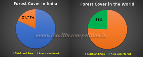
- The percentage of forest cover in India in terms of its total geographical area is - 21.71%*
- The area under forest cover in India - 7,13,789 sq km
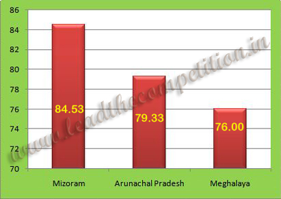
- The state with highest percentage of its geographical area under forests - Mizoram - 84.53%*
- The Union Territory with highest percentage of its geographical area under forests - Lakshadweep - 90.33%*
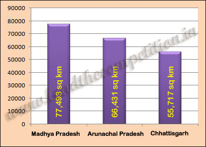
- The state with largest area under forests - Madhya Pradesh - 77,493 sq.km.*
- The Union Territory with largest area under forests - Andaman & Nicobar Islands - 6744 sq.km*
- The state with lowest percentage of its geographical area under forests - Haryana - 3.63%
- The state with least area under forests - Haryana - 1,603 sq.km.*
- The type of forest which constitutes the largest area of forests in India - Tropical Dry Deciduous Forest - 41.87%
*The above data is based on GoI Press release dated 08 Aug 2022. Refer this link
Forest Cover in India and World
TOP 3 STATES AREAWISE IN FOREST COVER
TOP 3 STATES PERCENTAGEWISE IN FOREST COVER